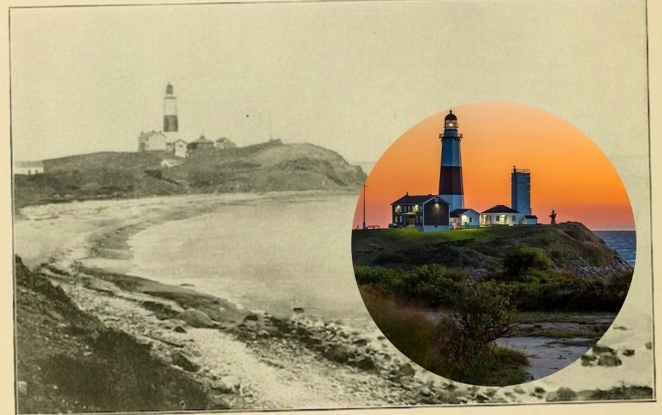
Most Long Islanders know Montauk Point is eroding.
But very few have ever seen just how much—until these two images are put side by side.
At first glance, it’s the same place. Same lighthouse. Same bluff. Same stretch of ocean at the eastern tip of Long Island. But look a little closer, and the difference becomes hard to ignore.
This isn’t just change. It’s loss you can actually see.
The View Most People Never Compare
The older image comes from a Long Island Rail Road promotional book called “Unique Long Island Camera Sketches,” published around the turn of the 20th century.
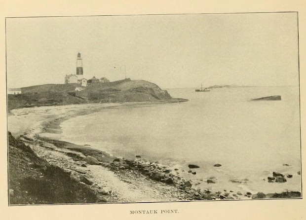
Back then, Montauk looked… different.
• The bluff stretched much farther out toward the water
• The slope down to the shoreline was wider and more gradual
• There was noticeably more land protecting the lighthouse
• The entire scene feels more stable than what you see today
This wasn’t just documentation. The LIRR used images like this to encourage people to travel east and experience Long Island’s natural beauty firsthand.
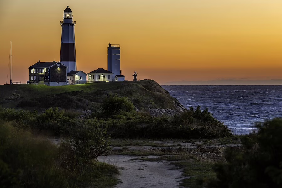
Now compare that to the modern photo.
• The bluff is tighter, steeper, and clearly cut back
• The lighthouse appears much closer to the edge
• That buffer of land seen in the older image is largely gone
• The landscape feels more exposed to the ocean
It’s the same location, but it tells a completely different story.
The Numbers Behind the Visual
Seeing the difference is one thing. Understanding it makes it hit harder.
• The Montauk Point Lighthouse was completed in 1796
• It was commissioned by President George Washington
• Originally, it stood about 300 feet from the edge of the bluff
• Today, that distance has shrunk to less than 50 feet in some areas
That change didn’t happen overnight.
It’s the result of centuries of storm-driven and constant natural erosion gradually eating away at the coastline.
And without intervention, it wasn’t going to stop.
The Effort That Kept It Standing
If you’ve visited Montauk recently, you’ve probably noticed the massive rock structures along the base of the bluff.
Those weren’t always there.
• A large-scale erosion control project was led by the U.S. Army Corps of Engineers
• The plan focused on protecting the most vulnerable areas with a stone revetment
• Construction began in 2021
• Major stone work was completed in 2022
• Final site restoration was finished in 2023
The goal was simple: prevent the eventual loss of the lighthouse and the surrounding park.
Because without that protection, the trend seen in these two photos was heading in a very clear direction.
Why This Spot Matters More Than You Think
Montauk Point isn’t just another scenic overlook.
• The lighthouse is one of the oldest in the United States
• It served as the first landfall for ships heading toward New York Harbor and Long Island Sound
• It’s listed on the National Register of Historic Places
• The surrounding area is a state park heavily used by fishermen and visitors
In other words, it’s not just a landmark. It’s part of Long Island’s identity.
And these two images capture something most people don’t realize when they’re standing there taking a photo.
You’re looking at a place that almost slipped into the ocean.
A Different Way to See Montauk
The next time you’re out at Montauk Point, take a second look at the bluff.
Try to picture what used to be there.
Because once you’ve seen these images side by side, it’s hard to unsee just how much has changed—and how close this place came to being something we only talked about in past tense.
Photo Credits
Old image: The image of Montauk lighthouse is from a book called “Unique Long Island Camera Sketches” created by the Long Island Railroad published around the turn of the 20th Century. The book was compliments of the LIRR and encouraged people to travel east to explore the beauty of Long Island.
New image: English: Montauk Point Light, Montauk Point, 2000 Montauk Hwy. Montauk The lighthouse at Montauk Point in New York, photographed from Camp Hero State Park, which is just Southwest of Montauk Point State Park. Taken just before sunrise. Ronald Diel, CC BY-SA 3.0 https://creativecommons.org/licenses/by-sa/3.0, via Wikimedia Commons