
Long before Richard Scarry became famous for Busytown, Lowly Worm, and generations of children’s books, he drew Long Island.
In June 1947, Holiday magazine published Long Island: An Interpretive Cartograph, a colorful illustrated map created by Scarry that attempted to capture the island’s identity just after World War II. The map now survives in the collection of the New York Public Library’s Lionel Pincus and Princess Firyal Map Division.
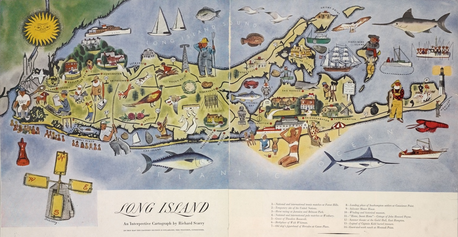
At first glance, it looks playful and almost cartoonish. But it also functions as a time capsule of what Long Island represented in the late 1940s: beaches, duck farms, fishing villages, horse racing, oysters, windmills, and endless summer tourism.
See the full resolution map by clicking here.
The map itself openly admits it distorts geography. A note at the bottom explains that “the eastern section is enlarged; the western, condensed.” In other words, Nassau County gets compressed while the East End sprawls dramatically across the page.
That alone says a lot about Long Island’s image at the time.
Some details that stand out immediately:
- Jones Beach appears packed with rows of tiny beachgoers.
- The Hamptons are portrayed as quiet seaside villages rather than today’s luxury real estate empire.
- Riverhead is represented by farming imagery, including a large farmer standing over the North Fork.
- Montauk features fishermen, a lighthouse, and references to horse ranches.
- Fire Island is shown mostly as open shoreline and recreation.
- Belmont Park and Forest Hills are highlighted as nationally important sporting destinations.
- Oystering, clamming, duck farming, and commercial fishing appear throughout the island.
Scarry also scattered historical references across the map, including:
- Theodore Roosevelt’s home at Oyster Bay.
- Walt Whitman’s birthplace.
- The old ship figurehead of Hercules at Canoe Place.
- Captain Kidd treasure legends.
- Southampton’s original English settlement.
The map was published only two years after the end of World War II, during a period when Long Island was rapidly changing. Suburbs were beginning to expand, parkways were bringing more visitors east, and tourism publications increasingly marketed Long Island as both a vacation destination and a place tied to colonial history and recreation.
What makes the piece especially interesting today is who created it.
Richard Scarry would later become one of the most recognizable illustrators in America, publishing more than 300 books with worldwide sales exceeding 100 million copies. He became known for turning everyday places into densely packed illustrated worlds filled with activity and tiny visual jokes.
You can already see hints of that style in this Long Island map.
There are oversized fish swimming offshore, tiny sailboats scattered across the Sound, and exaggerated local landmarks placed almost like stage props. Even the people feel like early versions of the busy characters that would later populate Busytown.
But unlike his later children’s books, this map was aimed at adults – specifically readers of Holiday magazine, a travel publication that often celebrated American destinations through art and illustration.
The result is less a precise map and more a curated portrait of Long Island in 1947.
Photo credit: “Long Island: an interpretive cartograph” by Richard Scarry, published in Holiday magazine (1947). From the Lionel Pincus and Princess Firyal Map Division, The New York Public Library Digital Collections.