You’re standing on the leftovers of a 60,000-year-old glacier. Seriously. Long Island didn’t just show up one day with bagels and beach traffic. It was bulldozed into place by a mile-thick wall of ice, slammed with waves, and is still getting a makeover from Mother Nature. Here’s the bizarre, beautiful, and sandy story of how our fish-shaped island came to be.
Long Island’s Basement is Older Than Dinosaurs
-
Beneath all that suburban sprawl lies ancient metamorphic bedrock that’s over 400 million years old.
-
This rock—visible up in Manhattan and the Bronx—is mostly hidden on Long Island, buried under layers of sand, clay, and glacial debris.
-
That bedrock tilts downward to the south and east and doesn’t form any noticeable hills or ridges on the surface.
-
On top of it sits a wedge of Cretaceous-period sediments (yes, from the same time as the dinosaurs), made of sand, gravel, and clay.
-
This wedge is thickest under Fire Island, where it’s more than 2,000 feet deep, and thins out toward Queens and Long Island Sound.
Then Came the Glacier
-
Around 60,000 years ago, the Laurentide ice sheet—specifically its Wisconsin Glacier portion—crawled down from the north and began sculpting what would become Long Island.
-
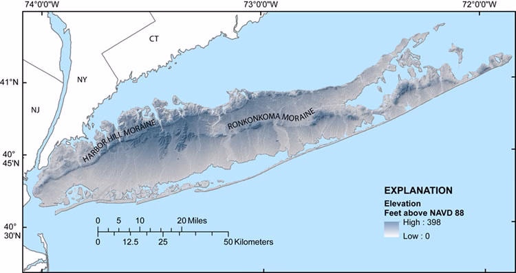
As it retreated, it dumped piles of gravel, rock, and dirt, forming two major ridges known as terminal moraines.
-
These glacial leftovers shaped the island’s spine and its iconic fish-like silhouette.
-
Long Island has alternated between being an island and a peninsula over the centuries, depending on sea level and sediment deposits.
-
Fossils are rare here, mostly because glaciers are not known for being gentle with prehistoric remains.
After the Ice, the Ocean Took Over
-
Once the glacier melted, the coastline began to evolve—and never really stopped.
-
Waves, tides, and storms chewed away at glacial sediments and started sculpting sandy shorelines.
-
Streams and rivers carried more material toward the sea, slowly reshaping upland areas and building up coastal zones.
Long Island’s Edges Are Always on the Move
-
Nowhere is this post-glacial chaos more visible than the south shore.
-
The Ronkonkoma moraine, near Montauk Point, has taken a beating from Atlantic storms for thousands of years.
-
The South Fork has actually shrunk by several miles due to constant wave erosion.
-
As the moraine erodes, currents push the sand and gravel westward—creating barrier beaches like Fire Island, Jones Beach, and Long Beach.
-
These beaches are built by wave action and currents, often forming offshore bars that drift west and grow over time.
-
Since Fire Island Lighthouse was built in 1844, the island has expanded five miles to the west.
Dunes, Grass, and Grit
-
Wind-blown sand forms dunes further inland, where beach grasses and shrubs help hold the sand in place.
-
These vegetated dunes act as natural armor, reducing storm damage and keeping the beaches from washing away.
Where the Water Gets In: Inlets and Lagoons
-
Barrier beaches are interrupted by inlets—natural channels that allow tides to flow in and out of the bays behind them.
-
Over time, marshes fill in behind the beaches, slowly connecting them to the mainland.
-
Behind Long Beach, you can still see this silting process in action, with narrow channels dividing marshy islands.
Drainage: The Island’s Subtle Stream Game
-
Long Island’s small size and elevation mean it doesn’t have major rivers—just lots of short streams and brooks.
-
Most freshwater runoff flows straight to the sea without forming big rivers.
-
The largest river is the Peconic, which runs east to west, unlike most others on the island.
-
Other notable rivers like the Carmans, Connetquot, and Nissequogue appear bigger than they are due to their estuaries—flooded valleys where freshwater mixes with salty seawater.
A Low Island with High Stakes
-
Long Island’s highest point is Jayne’s Hill in Suffolk County—soaring to a dramatic 401 feet above sea level.
-
With such a low profile, Long Island is vulnerable to flooding and rising sea levels. In the distant future, parts of it could be underwater.
Yes, We Get Earthquakes
-
While we’re not exactly on the San Andreas fault, Long Island has had its share of minor earthquakes. They’re usually small but still enough to rattle the dishes.
-
For a list of historical quakes, check out the earthquake archives. You might be surprised how often the ground has shaken under your feet.
Photo: United States Geological Survey (USGS), Public domain, via Wikimedia Commons.